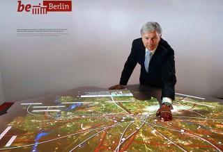
On 26 January the new interactive “Be Berlin” table in the Berlin Town Hall (Rotes Rathaus) was inaugurated by the Governing Mayor of Berlin, Klaus Wowereit. The table in the shape of the city of Berlin shows sights and stories of the Be Berlin campaign on a satellite map. Visitors can explore facts and figures and zoom into places like the Brandenburg Gate, the Olympic stadium or the new Airport Berlin Brandenburg International (BBI). The ART+COM patented multitouch surface enables many users to explore the content at the same time.
I created the screen design and the programming at ART+COM together with Felix Hardmood Beck (exhibition design/draft/consulting) and Hermann Klöckner (consulting).
This saturday evening the installation is open to the public during the Long Night of Museums. Felix and me are going to be there throughout the evening from 6pm to 2am in the night to answer your questions. We’re looking forward to seeing you there! Who can’t make it on saturday night or doesn’t happen to be in Berlin, can have a look at the table on each day the Town Hall is open to the public.
Interactive BeBerlin table
Foyer in front of the coat of arms hall (Wappensaal)
inside the Berlin Town Hall (Rotes Rathaus)
Entrance Rathausstraße
10178 Berlin Mitte
Long Night of Museums
Saturday, 31/01/2009
Further details and video on the project page.

